Lost in the Woods
There is blood on my hands. Dirt clings to my legs and face. Barbs grab at my ankles as I frantically try to make progress towards the track. I can hear them moving through the brush behind me, their sense of urgency as clear as mine. I see a flash of colour as one of them darts through the dense woodland and I lose my footing. I heave myself off the sturdy birch that caught my slide and leap down a small drop, praying I don't snag my ankle and the clawing brambles; now is not the time to take a tumble. I am starting to feel desperate, I must find it soon.
No, I am not being chased by some wild assailants or on the desperate hunt for some exciting treasure. I’m not even running the Barkley marathons….this is orienteering!...Although I might be doing it wrong...
In November I attended my first orienteering event organised by Newcastle and Tyneside Orienteers (NATO) set in the beautiful Simonside hills. A few months ago, one of the organisers of that event got in touch to let me know about a similar one scheduled for the 7th of April, organised by their neighbours to the South, the Cleveland Orienteering Klub (CLOK). The "Acorn" National Event at Eston Moor & Lazenby Bank. It looked like another good event, and another great opportunity to work on my navigation skills.
One of the courses, “Red”, was described as being “suitable for runners with limited navigational experience. It aims to give you a good run out with enough navigational challenge to make things interesting.” Sounds perfect for me!
With my pre-entry done online, I checked the website a week beforehand and got all the info I needed; parking, start location, and the vital cake sale details. I even had an allocated start time of 11:30. What I didn’t have, when it came to packing my bag the night before, was a compass!
Of the kit required: full leg cover; off-road shoes; whistle; waterproof jacket (weather dependant) and compass, the compass is pretty key, what with orienteering being first and foremost, a navigation challenge. I turned the house upside down looking but it was nowhere to be found. Oh the irony! Spending 2 hours looking in increasingly unlikely places (why wouldn't my compass be in the cupboard with the boiler?) was not how I planned spending the evening before the event.
Eventually I gave up looking and managed to arrange a loaner from a friend. Unfortunately the rental compass meant driving across Newcastle and back before heading to Eston Moor, just south of Middlesbrough. I gave myself plenty of time to make the journey and grabbed my backpack with my waterproof in, hoping I wouldn’t need it.
Unlike the previous event I had never been to the competition area before. All I knew about it was from the course description. It told of moorland, and woodland, steep slopes and relatively flat areas of good running. So, imagine how delighted I was to turn on the fog lights of my car for the first time ever as the A19 whisked me into the pea soup!
Thankfully the cloud had lifted by the time I pulled off Flatts Lane into the car park of the NHS offices which was transformed into the event HQ. The final details had advised a 1.7km walk from registration to the start, suggesting around 30 minutes be allowed to get there. With my dash across town for last minute kit and long drive in the fog I was left with...90 minutes to register and get there, maybe I was a tad early.
45 minutes later I had re-read the instructions and discovered that if I arrived at the start early they would fit me into the next available slot on my course. With only 3 others registered before the event I was confident they would squeeze me in. With my dibber on my finger (then the other finger, then back to the first one but on the inside of my hand) I left my bag in the car and departed for the start, compass and whistle in my pockets, where my course map was waiting for me.
On the way there I saw other competitors making their way to the start. They ranged from whole families there for a day out together, to serious looking orienteers in an array of different club colours. Orienteering does seem to be a sport open to all levels of fitness. Whether you can run a 100 mile trail race in less than 24 hours or your physical prime is a distant, black and white memory, you can test yourself against a course where mental agility and skill is arguably more important than physical prowess. I saw young families enjoying time in nature together getting muddy and learning how to navigate. I saw serious competitors out to do the best they could and battle for victory. There were athletes of an age where most would expect them to be tucked up inside on this cold April day with a nice pair of slippers and mug of coco, but here they were, a steely look in their eyes and the benefit of wisdom to aid them swiftly around the course. One person I passed at a few places, as the different routes criss-crossed on the hillside and moorland, was moving carefully but confidently with a pair of walking sticks and who I assumed to be her teenage grandson at her side, working together and enjoying themselves. I cannot think of another sport that is open to such diverse physical ability whilst getting people moving and experiencing the outdoors.
When I got to the start area I wasn't going to make the same mistake as last time. I placed my dibber in the unit labelled “clear” and listened for the beep. There were lines of maps and smaller control description sheets either side of the path. I was set away alongside some of the aforementioned serious looking orienteers in club colours who were on the blue and brown courses.
Then, a familiar sensation. Whilst the other two confidently darted off down a narrow path I stared dumbstruck at my map. Where is that starting triangle?! Ah there! But which way to go? Not that way...I hope nobody waiting at the start saw me turn around and set off after the other two who were already out of sight.
 |
| The illusive Kite with the control box on top. |
Making my way to control one I saw an orange and white kite just off the track. I was almost certain it wasn't the one I was looking for, it was next to trees not a crag as per the control description I was clutching tightly with my map. Never the less I had to check it, I’d be kicking myself if I walked past it only to have to come back later. The quick check showed it had a different number to the one on my control description card, but it wasn't a loss, my small detour revealed a nice direct line to the foot of the middle crag that I expected my target to be at. Sure enough, there it was. It seemed I needed a little more confidence in my ability. I put my dibber in the control box and listened for the beep. Having only used the system once before I was expecting to hear two beeps the same as last time. What I got was continuous beeping. Was that right? Had I not cleared my card correctly at the start? When I was handed my dibber they said I didn't need to punch in at registration as it had already been done for the pre-entries. Had mine been missed and I was going to be told at the finish that my run didn’t count? I supposed I would find out at the end.
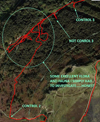
Control two was simply a case of following the nearby track a short way downhill. Using a prominent path junction as a guide I quickly found the kite hiding in a nearby depression. Next up, the map showed me control three to the North East. I could either continue down the path I just left, picking up another path which would take me close to the control, or I could contour around from where I was an drop down on top of the control. The second option was more direct and looked to involve less climbing, decision made.
That's where it started to go wrong. Instead of following the clear path and being able to keep a good awareness of my position I crashed into the undergrowth trying to follow an approximate bearing and maintain height. Not easy to do in rough knee deep foliage that insists you change direction to every few steps to navigate through it. I had also been caught out by the map. On orienteering maps a white area, unlike most maps I have used, does not denote open ground, but woodland. So what I had quickly taken to be open ground with a bit of a slope and a few depressions scattered throughout was actually woodland with undergrowth hiding the true nature of what was underfoot.
After passing some small pools of water shown on my map I was still feeling confident but it didn't last. I realised that I had no backstop; no feature that if I hit it told me I had overshot my target. All I had to work from was a path, which in this vegetation I could easily have crashed right over without noticing. I didn't think I had gone too far yet, but I caught a glimpse of the main track below me and saw what looked like the woodland equivalent of spaghetti junction. My map showed that control three was just past a feature like this. I decided to head down there and look for the control from the track.
I checked back and forth with no luck, and concluding that I must be close by set off back into the trees in search of the illusive kite. My control description sheet told me it was located on or in a “saddle”, whatever that was . After a few minutes I was starting to worry. The ground was getting more uneven and seemed to be made of endless depressions, none of which I could see from the contours of my map (I later found out that the small triangular symbols were trying to tell me about these small craters but I hadn’t noticed them!). I must be in the wrong place. By the time I decided once more to head down to the track below and try and re-establish my position I had cut my hand on a bramble and seen at least three other competitors dart through the trees above me. A decisive move back towards the track had me sliding into trees and leaping hastily down small drops. I was starting to flap a little.
I tried reminding myself that this was exactly the reason I signed up, to challenge and test myself. Turning up, navigating perfectly for an hour and having a nice run wasn't going to teach me anything. It didn't help, I was still frustrated. I clearly wasn't the only one though, as I jogged up and down the path past the burnt out car (it really was a very nice area) there was another guy who looked how I felt and was doing a similar dance.
Promising myself that if I saw the remains if that car again I would officially admit I was having a bad day out (but probably not as bad as the owner of that car once had), I went with my initial gut instinct, that I hadn't gone far enough before dropping down. Just past the next bend in the track there was old brick tunnel jutting out of the landscape. Could you describe the top of that as “saddle” shaped? Worth investigating! No joy. But, whilst there I spotted something on my map. The tunnel. I had been right all along, I had dropped down to the track around two thirds of the way to the control. The map showed four boulders next to the trail just before the control and they quickly came into view as I ran. With great relief I had confidence in my position and and more importantly the correct control kite.
Control four was a simple case of following the track until I came to a path junction. I generally don't like using paths as navigation features (they have a habit of not being very obvious, not even being there, or there being extra ones not shown on the map!). As that aversion had got me into my last mess, and the path I was looking for this time also had steps, I gambled that it was a safe approach to take. It was. After a satisfying half mile run along the track trying to recover some lost time I found the control easily and was soon climbing the steps towards control five.
Most of the remaining controls kept me on the relatively flat and open moorland but the placement gave some fun navigation as I squeezed through gauze lined gullies and hand-railed along (and sometimes in) ditches to track them down.
Some of the other competitors appeared and disappeared never to be spotted again, others popped up time and time again as our courses intertwined (or one of us was going the wrong way) but very little in the way of communication passed between us, too much concentration on the map was needed to permit more than a half smile or passing nod of the head. Orienteering is a serious business.
With control point 11 successfully (I assumed) dibbed, it was time for a dash through the trees to the waiting finish control in the open ground close to the car park. I reached it just ahead of a family as they completed a shorter course together, the two young children delighted to be muddy and clearly enjoying the competitive element.
I had ran, walked, paced and leapt just over 4 miles in total with a little over 700ft of climbing in a time of 61:40. It was not a fast 4 miles by my usual standards but it had still felt like hard work. An interval session for mind and body with a few good hills and plenty of heather bashing thrown in for good measure.
Time to find out if the extra beeping was trying to tell me I had an error! I headed for the registration tent where a final control box awaited labelled “download”. The difference with this one was that it was connected to a computer and a small printer. I put the dibber in the box and waited, instead of the instant beeping there was a pause...then beeps, the same constant beeping I had got all day. I was told to take my dibber out which I did and handed it back to the volunteer. This was going to be the moment when they told me it hadn't worked, she was about to look at her laptop screen, knit her eyebrows together sympathetically and tell me “better luck next time”.
Bbbzzzzz
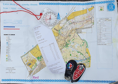
The printer had sprung to life! With a pleasant “There you go. Well done!” I was handed my printout, a split time for each control showing I had successfully completed the course. Not only that, but I was the quickest of the two competitors to have finished so far. Not bad for an orienteering novice. By the end of the day, thanks mostly to my detailed inspection of the woodland between controls two and three, I was to slip to second overall on the Red course. It’s great to finish second, but what I like most is that because it is a small field, on a course that attracts mostly juniors and others still learning the sport, I don't feel any competitive pressure. I am not comparing myself to others in the results in the same way I would if it was a running event. I enjoyed it purely for the challenge and as a chance to improve an important skill.
 |
| I had to use my car keys to stop the wind blowing everything away for the picture 🤦♂️ |
I learnt a few good lessons that day:
- A longer route with simpler navigation and easier terrain should always be properly considered over the shorter direct route;
- RTFM (Read the … Map);
- Running and looking left or right for a control hidden in the foliage and not tripping on rocks is a skill that needs more practice;
- Just because you have checked the obvious place for your compass to be doesn't mean that it wasn't there all along, in the side pocket of your bag (yes that bag, the one that was sat on the back seat of your car all day!).


Comments
Post a Comment
Enjoy the post or think you have just wasted your time? Let me know!